Thursday, September 27, 2012

Accretionary Wedge #50: Field Camp / Trip Moments

Evelyn Mervine is hosting the 50th anniversary edition of the Accretionary Wedge at her blog Georneys. The topic of the wedge this month is a nostalgic one: talk about a fun field moment. Wow! There have been so many fun moments, in fact, every time I have been to the field its been fun...even the days that didn't seem so great at the time now are just fond memories.

I remember the first field trip of my geology undergrad. Looking even further back I remember the first time I went mineral collecting in a quarry (I was only 10). Over the years I have been in countless old quarries and mines, stopped at hundreds of outcrops and been on many educational geo field trips around North America and the Caribbean. So really the problem is not to tell a fun field story, but how can I tell just one?! I can't!

My first trip

My first geology related field trip was to a limestone quarry an hour north of my home. I was 10 years old and was a major geology nerd as a kid...not much has changed. I had just joined up with the Peterborough Mineral and Fossil Club and this was one of the many collecting trips that the club went on each weekend. The trip was to an active quarry so I had to make sure that I was wearing a hard hat and steel toe boots. We were there to collect pyrite cubes. In hindsight, this was the perfect first trip for me. We were collecting flashy gold pyrite cubes in the limestone which made things easy for me since I didn't have the strength back then to swing my hammer like I do these days. Plus, there was the certainty of finding something that looked cool and was easy to identify. I have been on many collecting trips since and usually the rocks are not so soft and the minerals are not so flashy. Unfortunately, I don't have pictures of my first trip so you'll just have to imagine me, my dad, and about fifteen retired men and women in the quarry wandering around looking for the glint of pyrite.   

My first undergrad trip

The first trip of my geology degree was to a spot not far from the school. I went to Queens University in Kingston, Ontario and the trip was part of a second year course aptly titled "Field Methods". The course involved weekly five-hour field trips to local sites were we would map, measure and identify the rocks in the area. It was a hard course, especially since we were all new to the field and were being asked to do a lot, but in hindsight it was a fantastic learning experience. Fond memories include the prof continually yelling from underneath his umbrella and a cloud of smoke "get in the ditch". But I digress. Our first trip was just up the road to place called Joyceville, where we took notes on the syenite outcrop, made a map and talked about joint sets and glacial striations. One thing I really remember was the rain. It poured the entire five hours and at the end all we could do to stay warm was huddle in groups of five or six and try to keep our field books dry enough to write. Sound familiar? I think pretty much every rookie geologist has an experience like this. If only I could find the field book that has those notes in them. 

Bermuda trip

Fast forward a few years to the start of my final year of undergrad. I was lucky enough to go on a trip to Bermuda as the conclusion to my carbonate sedimentology class. It was led by world experts in the field and is in fact known across Canada as the best carbonate trip in the country for students and professionals alike. The beauty of carbonate systems is twofold: "they are born, not made"  and that you can see their development in action. All you have to do is strap on a snorkel and jump overboard, which is exactly what we did. This trip is a highlight of my geological career so far and was one of the most enjoyable field experiences I have had...how can you beat doing geology in the Caribbean and spending all day snorkelling around reefs?

Doing field work!
Thrusting

This became a weird tradition for upper year field trips in the department, at least when my friends and I were on the trips it did. I have no idea if it goes on to this day. However, let me explain before you get any strange ideas about what my friends and I were up to on these trips. We were working in Quebec and upstate New York looking at evidence of the Taconic orogeny during the Ordovician. If you have ever done field work in these areas you know that thrust faults abound. In fact, the whole area is nothing but thrust faults. So, when we would do group photos everyone would lean in the direction of thrust...essentially creating a human thrust fault. See the pictures below...

Everyone do the thrust! Arm gestures are crucial.

Extreme group thrusting!
TA'ing

Things are different now. No longer am I the cold, wet undergrad trying not to rip their map. I am the one yelling "get in the ditch" these days, and trying to coach the next generation of geologists as they learn some field skills while trying my best not to laugh as they bumble along. Being a field trip leader is as much fun as being on a trip. I really enjoy teaching people and explaining all of the amazing things that rocks, sediment, etc. can tell us.

I have been on lots of other trips as well and I enjoy telling stories about them all so perhaps I'll post in the future with some more field trip moments.

Thanks for reading!

Matt

Monday, September 24, 2012

Geology Photo of the Week #5 - Sept 23-29

The fifth edition of the Photo of the Week is of a fantastic trace fossil that I was shown while on a 4th year field trip in my undergrad. We were travelling around Quebec looking at evidence of the Sauk-Tippecanoe unconformity and the Taconic orogeny during the Ordovician. We traveled from Kingtson to Quebec City and spend a few days in the area exploring all of the fantastic geology around and even within the city.

The trace fossil, which is not of an actual organism but rather evidence of its behaviour, was seen at a stop about half way to Quebec City. I don't want to give away the exact location since we hid the fossil around the outcrop for future groups of students to use when they visit. The fossil is called Rusophycus and is a trilobite resting trace. Trilobites were a very common, bottom-dwelling organism during the Ordovician, which ran from 488-443 million years ago. Sometimes, the trilobites, which had a hard exoskelton would dig themselves little holes, presumably to rest in, and these are preserved today as deep indentations in the rock that were then filled by mud and preserved.

A superb Rusophycus trace fossil in limestone. (Photo: Matt Herod)
File:Kainops invius lateral and ventral.JPG
Trilobites (Source: Wikimedia Commons)
Cheers and thanks for reading!

Matt

Monday, September 17, 2012

Geology Photo of the Week #4 - Sept 16-27

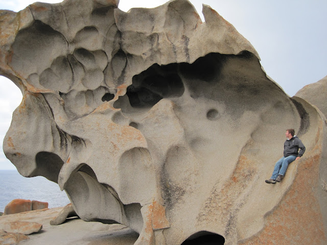
This edition of photo of the week is of some pretty special rocks...in fact you might even say they are remarkable. Pardon the pun, but the focus of the pictures this week is the Remarkable Rocks, located in Flinders Chase National Park on Kangaroo Island just of the coast of South Australia. The Chase, as it is referred to by island residents, is a phenomenal park. It has beautiful hiking, great wildlife, such as New Zealand fur seals and the rocks. 

The rocks sit isolated atop a large granite outcrop next to the ocean. They are a gorgeous example of the incredible erosive power that wind, sea spray and water have on a landscape. The odd cavities and shapes are formed by these forces. The rock itself is 500 million year old Cambrian granite and weathering and erosive processes have formed these incredible sculptures over time. 

If you are ever in South Australia a trip to Kangaroo Island, the Chase and the Remarkable Rocks should be on your list!

My friend James posing under one of the odd overhangs. 

So damn cool!!!


Me sitting on one of the rocks
Thanks for reading! Has anyone else got good examples of "remarkable rocks"?

Matt

Monday, September 10, 2012

Geology Photo(s) of the Week 3 - Sept 9-15


This edition of "Photo of the week" is of something a bit closer to home than previous editions have been. The pictures below, excluding the sunset, were taken by me while I was TA'ing a first year geology field trip to Gatineau Park, just outside of Ottawa. The river in the distance in the photos is the Ottawa River. Of course, these photos have a geological interest as well: they show a great view of the Ottawa-Bonnechere graben. For any non-geo types reading this post a graben is the same as a rift valley.

In the Mesozoic a rift system started to open in the Ottawa area. However, this rift did not fully separate and no new continent was formed. The ground between the rift dropped and this is called a graben. Notice the sudden change between the flat plain of the Ottawa river to the Gatineau hills. That is the edge of the graben. 

A look at the edge of the graben from Champlain Lookout in Gatineau Park.

Google Terrain image of the Ottawa-Bonnechere Graben. Note the hills on either side of the flat area. 
A nice view from Champlain lookout showing the Ottawa River. 

Sunset in Gatineau Park
Thanks for reading,

Matt

Tuesday, September 4, 2012

Geology Photo of the Week 2 - Sept 2-8, 2012

Welcome back to school everyone! I hope that you all had great long weekends as well as great summers and productive field seasons! 

This weeks photos were taken during my recent trip to Whitehorse to do field work. I was collecting water samples in the Wolf Creek watershed just outside of town. Wolf Creek flows past an old copper mining district and the Trans-Canada Trail passes right past the old open pit mines along what is know as the Copper Haul Road. The trail is littered with boulders and rocks like the one below, which came from the mines and are heavily discoloured by copper minerals. I can't confirm the mineralogy on these ones but I suspect that it is a combination of malachite and chrysocolla. The blue box on the top of the rock is my conductivity meter for scale.

A large boulder absolutely full of copper alteration minerals.  (Photo: Matt Herod)

A close up of some of the discolouration by copper minerals. Pretty sure that is is malachite and maybe some chrysocolla. (Photo: Matt Herod)
Copper was discovered in Whitehorse by miners/prospectors on their way to Dawson City during the gold rush. The first claim was staked in 1897 and numerous others were staked in the following years, some by Sam Magee, of poetry fame. Mining of the claims began and was the first industry that the town of Whitehorse was built around. The early mining days continued until 1920 and ~150,000 tonnes of copper were extracted.

The development of better exploration techniques in modern times allowed for the discovery of additional copper reserves and mining began again and ran from 1967-1982 with an additional 9.8 million tonnes of copper extracted as well as some silver and gold.

Thanks for reading and enjoy the first week back!

Matt